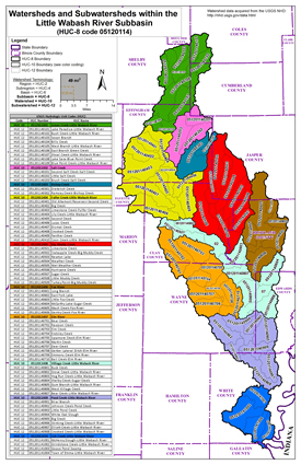
The river rises in Coles County near Mattoon and flows generally southwardly through Shelby, Effingham, Clay, Richland, Wayne, Edwards and White counties, past the towns of Louisville, Golden Gate, Carmi and New Haven. It enters the Wabash River on the common boundary of White and Gallatin counties, about 4 miles (6 km) southeast of New Haven. The drainage area of this watershed covers 80 square miles.
LITTLE WABASH RIVER WATERSHED (HUC 05120114)
The Little Wabash River is a 240-mile-long (390 km) tributary of the Wabash River in east-central and southeastern Illinois.

Flood Risk Review Meetings, February 2020
Three Flood Risk Review meetings were held for the Little Wabash River Watershed; one each in Flora (Clay County), Effingham (Effingham County), and Fairfield (Wayne County).
- Meeting Presentations:
 Clay County (PDF)
 Effingham County (PDF)
 Wayne County (PDF)
- Maps:
- Clay County
 Countywide Index (PDF)
 Countywide Workmaps (PDF)
 Hydrology Workmap (PDF)
 Zone AE Hydraulic Workmap (PDF)
- Crossville
 Hydrology Workmap (PDF)
 Zone AE Hydraulic Workmap (PDF)
- Effingham County
 Countywide Index (PDF)
 Countywide Workmaps (PDF)
 Hydrology Workmap (PDF)
 Zone AE Hydraulic Workmap (PDF)
- Fairfield
 Workmap (PDF)
 Comparison Workmap (PDF)
- Little Wabash River Hydrology Workmaps
 HMS Hydrology Workmap (PDF)
 GAGE Hydrology Workmap (PDF)
- Wayne County
 Workmap (PDF)
- Clay County
The information below is for historical reference. The Discovery process for this watershed is complete and the data is considered archival.
Discovery Material, August 2016
- Meeting Presentations by:
- Discovery Map:
 Discovery Report (PDF)
 Discovery Database (ZIP)

