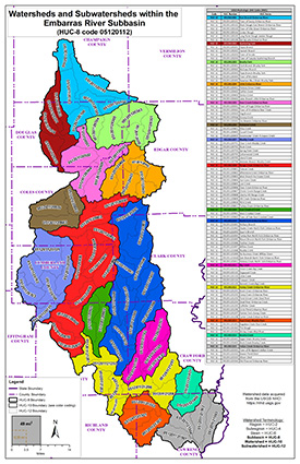
The Embarras River watershed is located in east-central and southeastern Illinois. The 195-mile-long Embarras River drains about 2,435 sq. miles.
EMBARRAS RIVER WATERSHED (HUC 05120112)
The Embarras River watershed includes parts of Champaign, Douglas, Vermilion, Edgar, Coles, Cumberland, Clark, Jasper, Effingham, Crawford, Richland, and Lawrence Counties in Illinois.
Embarras River - Tributaries
Project Initiation Coordination Call
5/13/2025
- Meeting Recording:
 Watch Video (hosted on Illinois Media Space)
 Download MP4 (183 MB)
 Meeting Presentation (PDF)
Embarras River - Mainstem
Project Initiation Coordination Call
4/10/2024
- Meeting Recording:
 Watch Video (hosted on Illinois Media Space)
 Download MP4 (197 MB)
 Meeting Presentation (PDF)
Press Releases
Water survey to analyze flood risks in Clark, Coles, Crawford, Cumberland, Jasper, Lawrence counties
May 23, 2025
The Illinois State Water Survey is continuing data development for the Embarras River watershed as part of a multiple-phase study to help local communities identify areas of high flood risk for flood mitigation planning. Results from the new study will be used to update the Federal Emergency Management Agency's Flood Insurance Rate Maps and Flood Insurance Studies report which typically depict floodplains, including the 1-percent-annual-chance (100-year) and 0.2-percent-annual-chance (500-year) flood hazard areas.
Water Survey to analyze flood risks in eight east-central and southeastern Illinois counties
Jan 27, 2023
Illinois State Water Survey (ISWS) crews are starting to collect data within the Embarras River watershed as part of a multiple-phase hydrologic and hydraulic study to help local communities identify areas of high flood risk for flood mitigation planning. Results from the new study will be used to update the Federal Emergency Management Agency (FEMA) Flood Insurance Rate Maps (FIRMs), which typically depict the 1 percent and 0.2 percent annual-chance floodplains.

