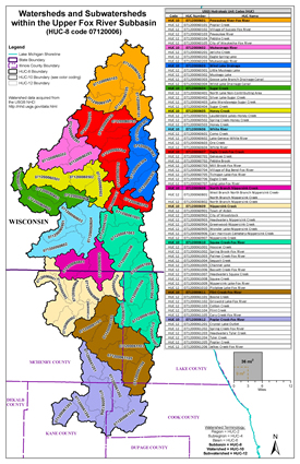
The Upper Fox Watershed is located in the far northeastern part of Illinois and the southeastern part of Wisconsin. The entire watershed covers 1,543 square miles, of which the Illinois portion covers 617 square miles, or approximately forty percent.
UPPER FOX RIVER WATERSHED (HUC 07120006)
The Upper Fox Watershed is located in the southeastern part of Wisconsin and in the far northeastern section of Illinois. The watershed area includes parts of Kenosha, Racine, Walworth, and Waukesha Counties in Wisconsin and Cook, Kane, Lake and McHenry Counties in Illinois. Two Discovery meetings were held in both Illinois and Wisconsin.
Nippersink Creek & Tributaries
Flood Risk Review Meeting
6/7/2023
- Meeting Recording:
 Watch Video (hosted on Illinois Media Space)
 Download MP4 (214 MB)
 Meeting Presentation (PDF)
Poplar Creek, Spring Creek, & Tributaries
Flood Risk Review Meeting
10/4/2018
The information below is for historical reference. The Discovery process for this watershed is complete and the data is considered archival.
Action Discovery Materials
September 2013
 Updated Discovery Report for Upper Fox Watershed (PDF)
 Upper Fox North Action Discovery Map (PDF)
 Upper Fox South Action Discovery Map (PDF)
 Areas of Mitigation Interest (AoMI) Dataset for Upper Fox Watershed (ZIP)
October 2014
- Action Discovery Meeting Presentations:

