TWI shows areas with increased accumulated runoff potential, and areas with low slope and large upslope contributing areas.
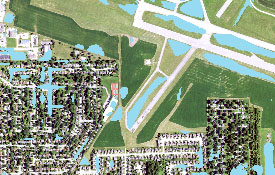
TWI areas shown in blue in a suburban area.
A high resolution digital elevation model from LiDAR was used to develop TWI.
Disclaimer: The Topographic Wetness Index (TWI) is intended solely for informational purposes and does not assess flood risk from riverine sources. It should not be construed as a replacement for official flood hazard information provided by products such as FEMA's Flood Insurance Rate Maps (FIRM). TWI offers an approximation of locations where stormwater runoff might accumulate based on available topographic data at the time of analysis. However, it does not consider the influence of storm sewers and other drainage infrastructure. It is imperative to note that TWI is not suitable for engineering, design, or permitting applications. Users are strongly advised against relying on TWI for such purposes.
The Topographic Wetness Index (TWI) is an index or indicator of the effect of local topography on runoff flow direction and accumulation. The index is a function of both the slope and the upstream contributing area.The computation of TWI is performed using both geographic information systems (GIS) and Python, a programing software used to enhance computing capabilities. The indices help identify rainfall runoff patterns, areas of potential increased soil moisture, and ponding areas.
With support from FEMA and using high resolution DEMs derived from LiDAR, Illinois State Water Survey generated the index for the Illinois counties of DuPage and Will (see report), and with the support of National Resources Conservation Service (NRCS) subsequently generated the index for all remaining Illinois counties. The Illinois Department of Natural Resources (IDNR) funded the creation for Lake County as part of their Coastal Management Program. While TWI is usually viewed in raster format, ISWS is distributing a version in polygon format for easier access and use.
For most counties, two versions of TWI in shapefile GIS format are contained in the downloadable zip file. TWI was computed using a bare earth Digital Elevation Model (DEM) so TWI polygons mistakenly overlap many building footprints. The first version (with the suffix v0) contains these overlapping polygons. In a second version (with the suffix TWI), overlapping areas were subsequently removed during post processing using building footprints.
This first release version is a direct product of computer processing without manual examination of areas across the state and may therefore inaccurately display areas such as lakes, rivers, and areas where road culverts were missing from the LiDAR.
Select a county of interest to download the shapefile. Please see our disclaimer.
TWI shows areas with increased accumulated runoff potential, and areas with low slope and large upslope contributing areas.
TWI areas shown in blue in a suburban area.
A high resolution digital elevation model from LiDAR was used to develop TWI.
 Copyright ©
2024
- All Rights Reserved - University of Illinois Board of Trustees | Email CHAMP | (217) 244-3372
Copyright ©
2024
- All Rights Reserved - University of Illinois Board of Trustees | Email CHAMP | (217) 244-3372
Template by OS Templates