Flood Event Story Maps
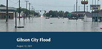
Gibson City Story Map
On August 12, 2021 a line of thunderstorms developed along southern Ford County, IL. Nearly 10 inches of rain fell in under 10 hours. This story map includes a model simulation produced by the Illinois State Water Survey, which shows the progression of the flood in Gibson City from the morning to the evening of August 12th. Photos taken during the flood are compared to the model results.
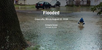
Greenville Story Map
On August 12, 2019, Greenville, Illinois received 9.34 inches of rain in 12 hours. This story map includes a model simulation produced by the Illinois State Water Survey, which shows the progression of the flood in Greenville. Photos taken during the flood are compared to the model results.
Informational Story Maps
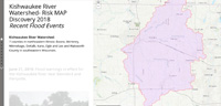
Kishwaukee River Watershed
This story map, made in Fall 2018, describes flood events that occurred in the Kishwaukee River watershed from 2015-2018. Impacted communities include Belvidere, Cherry Valley, and Sycamore.
Story Map Topic Locations
What is a Story Map?